
These are the types of storms that provide NOAA and many other weather forecast agencies a ton of trouble to predict and the type that catches the people of coastal Texas, Louisiana, Mississippi Alabama and the Florida panhandle off guard and unprepared.
Weather.JayCTheriot.Com will be paying special attention to this storm and will relay and detail information as it becomes available.
It isn’t time to freak out yet. But, you may want use this as an opportunity to check the status of your weather preparedness.
Thanks,
Jay C. “Jazzy J” Theriot
From the National Hurricane Center:
ZCZC MIATWOAT ALL
Forecaster Pasch/Bucci, National Hurricane Center
TTAA00 KNHC DDHHMM
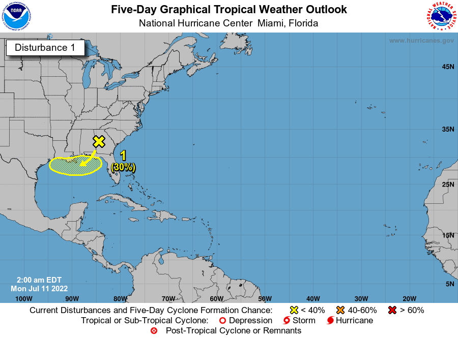
Tropical Weather Outlook
NWS National Hurricane Center Miami FL
200 AM EDT Mon Jul 11 2022
For the North Atlantic…Caribbean Sea and the Gulf of Mexico:
1. Northern Gulf of Mexico:
A surface trough of low pressure is expected to form in a couple of
days over the northern Gulf of Mexico, partially related to a
decaying frontal boundary currently located over the southeastern
United States. Some slow development of this system is possible if
it remains offshore during the middle and latter part of the week
while it moves little. Regardless of development, heavy rains will
be possible along portions of the northern Gulf coast from Louisiana
to the Florida Panhandle over the next several days. For more
information about the potential for heavy rain, please see products
issued by your local National Weather Service office and the Weather
Prediction Center.
* Formation chance through 48 hours…low…near 0 percent.
* Formation change through 5 days…low…30 percent.
Products from the Weather Prediction Center can be found at
wpc.ncep.noaa.gov and local National Weather Service products can
be found at weather.gov
Leave a Reply