
TTAA00 KNHC DDHHMM
Tropical Weather Outlook
NWS National Hurricane Center Miami FL
200 AM EDT Mon Jun 1 2020
For the North Atlantic…Caribbean Sea and the Gulf of Mexico:
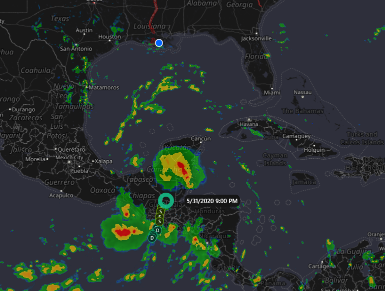
1. The remnants of Eastern Pacific Tropical Storm Amanda are currently
located inland near the Guatemala-Yucatan Border. This large
disturbance is forecast to move slowly northward this morning,
followed by a northwestward motion later today, and the center of
the low pressure system could emerge over the southeastern Bay
of Campeche by this evening. If the remnants move back over water,
environmental conditions appear conducive to support some
development, and a new tropical depression could form while the
system moves little through the middle of this week. Regardless of
tropical cyclone formation, heavy rainfall is likely to continue
over portions of southern Mexico, Guatemala, El Salvador, Belize,
and western Honduras during the next few days. For additional
information on the rainfall threat, see products from your national
meteorological service.
* Formation chance through 48 hours…medium…60 percent.
* Formation chance through 5 days…high…70 percent.
Today marks the first day of the Atlantic hurricane season, which
will run until November 30. Long-term averages for the number of
named storms, hurricanes, and major hurricanes are 12, 6, and 3,
respectively.
The list of names for 2020 is as follows:
Name Pronunciation Name Pronunciation
————————————————————-
Arthur AR-thur Laura LOOR-ruh
Bertha BUR-thuh Marco MAR-koe
Cristobal krees-TOH-bahl Nana NA-na
Dolly DAH-lee Omar OH-mar
Edouard ed-DWARD Paulette pawl-LET
Fay fay Rene re-NAY
Gonzalo gohn-SAH-loh Sally SAL-ee
Hanna HAN-uh Teddy TEHD-ee
Isaias ees-ah-EE-ahs Vicky VIH-kee
Josephine JOH-seh-feen Wilfred WILL-fred
Kyle KY-ull
Two tropical storms, Arthur and Bertha, already formed this year in
May. The next named storm that develops this season will be
Cristobal.
This product, the Tropical Weather Outlook, briefly describes
significant areas of disturbed weather and their potential for
tropical cyclone formation during the next five days. The issuance
times of this product are 2 AM, 8 AM, 2 AM, and 8 PM EDT. After the
change to standard time in November, the issuance times are 1 AM,
7 AM, 1 PM, and 7 PM EST.
A Special Tropical Weather Outlook will be issued to provide
updates, as necessary, in between the regularly scheduled
issuances of the Tropical Weather Outlook. Special Tropical
Weather Outlooks will be issued under the same WMO and AWIPS
headers as the regular Tropical Weather Outlooks.
A standard package of products, consisting of the tropical cyclone
public advisory, the forecast/advisory, the cyclone discussion,
and a wind speed probability product, is issued every six hours
for all ongoing tropical cyclones. In addition, a special
advisory package may be issued at any time to advise of
significant unexpected changes or to modify watches or warnings.
The Tropical Cyclone Update is a brief statement to inform of
significant changes in a tropical cyclone or to post or cancel
watches or warnings. It is used in lieu of or to precede the
issuance of a special advisory package. Tropical Cyclone Updates,
which can be issued at any time, can be found under WMO header
WTNT61-65 KNHC, and under AWIPS header MIATCUAT1-5.
All National Hurricane Center text and graphical products are
available on the web at https://www.hurricanes.gov. You can also
interact with NHC on Facebook at https://www.facebook.com/NWSNHC.
Notifications are available via Twitter when select National
Hurricane Center products are issued. Information about our
Atlantic Twitter feed (@NHC_Atlantic) is available at
https://www.hurricanes.gov/twitter.shtml.
Forecaster Stewart

Leave a Reply