
Invest 98 current imagery and analysis from NOAA.


Tropical Weather Outlook Text
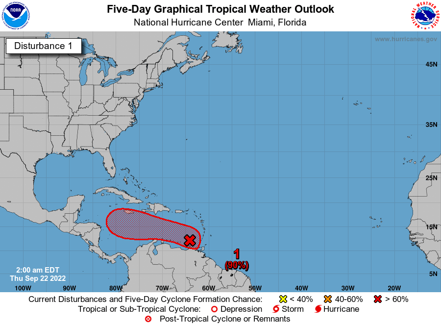
ZCZC MIATWOAT ALL
TTAA00 KNHC DDHHMM

Tropical Weather Outlook
NWS National Hurricane Center Miami FL
200 AM EDT Thu Sep 22 2022

For the North Atlantic...Caribbean Sea and the Gulf of Mexico:

Active Systems:
The National Hurricane Center is issuing advisories on Hurricane
Fiona, located several hundred miles southwest of Bermuda, and on
Tropical Storm Gaston, located several hundred miles west of the
Azores.

1. Southeastern Caribbean Sea:
Showers and thunderstorms continue in association with a tropical
wave located over the far southeastern Caribbean Sea.  Although
upper-level winds are currently inhibiting development, the
upper-level wind pattern ahead of the system is forecast to become a
little more favorable in a couple of days, and a tropical depression
is likely to form at that time.  The disturbance is forecast to move
west-northwestward across the eastern Caribbean Sea during the next
day or two, and be over the central Caribbean Sea this weekend.
Regardless of development, locally heavy rainfall and gusty winds
are likely to affect the Windward Islands this morning. These
impacts are likely to spread to northern Venezuela, northeastern
Colombia, and the ABC island chain during the next couple of days.
* Formation chance through 48 hours...high...70 percent.
* Formation chance through 5 days...high...90 percent.

2. Eastern Tropical Atlantic:
Showers and thunderstorms located near the west coast of Africa are
associated with a tropical wave that is expected to move over the
warm waters of the far eastern Atlantic later today.  Thereafter,
environmental conditions are forecast to be conducive for some
development, and a tropical depression could form by this weekend
while the system moves slowly northward, between west Africa and the
Cabo Verde Islands.
* Formation chance through 48 hours...medium...60 percent.
* Formation chance through 5 days...medium...60 percent.

3. East Central Tropical Atlantic:
A broad area of low pressure located several hundred miles
west-southwest of the Cabo Verde Islands continues to produce
disorganized showers and thunderstorms.  Despite marginal
environmental conditions, some slow development of this system is
possible over the next several days while it moves slowly
northwestward or northward over the tropical Atlantic.
* Formation chance through 48 hours...low...20 percent.
* Formation chance through 5 days...low...30 percent.

Forecaster Roberts
Atlantic Tropical Weather Discussion
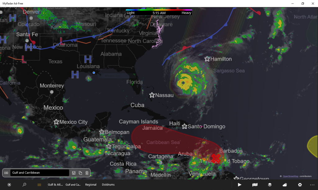
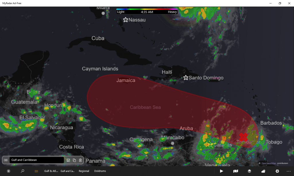
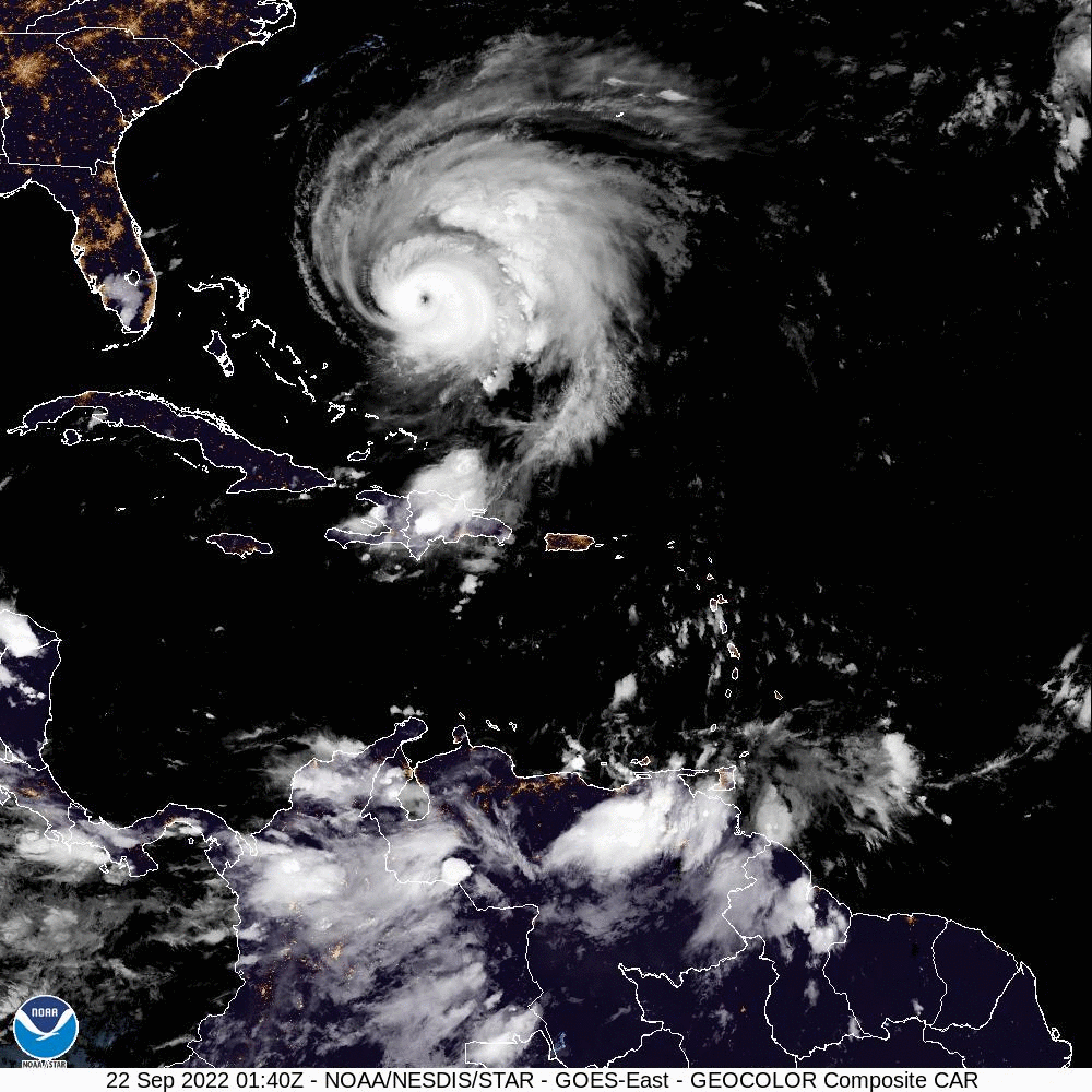
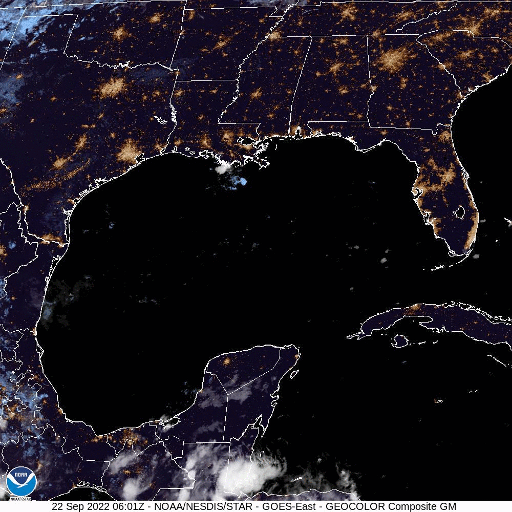
648
AXNT20 KNHC 220451
TWDAT

Tropical Weather Discussion
NWS National Hurricane Center Miami FL
0605 UTC Thu Sep 22 2022

Tropical Weather Discussion for North America, Central America
Gulf of Mexico, Caribbean Sea, northern sections of South
America, and Atlantic Ocean to the African coast from the
Equator to 31N. The following information is based on satellite
imagery, weather observations, radar and meteorological analysis.

Based on 0000 UTC surface analysis and satellite imagery through
0430 UTC.

...SPECIAL FEATURES...

Major Hurricane Fiona is centered near 26.6N 71.2W at 22/0300
UTC or 480 nm SW of Bermuda moving N at 9 kt. Estimated minimum
central pressure is 934 mb. Maximum sustained wind speed is 115
kt with gusts to 140 kt. Numerous strong convection is within
150 nm of the center in the E semicircle and 75 nm W semicircle.
Numerous moderate convection is elsewhere within 300 nm NE
quadrant, 240 nm SE quadrant, 90 nm SW quadrant and 120 nm NW
quadrant. A Sofar drifting buoy measured significant wave
heights of 38 ft at 21/1700 UTC. NOAA buoy 41047 at 27.5N 71.5W
is measuring significant wave heights of 30 ft at 22/0340 UTC.
Peak seas near Fiona are currently estimated to be 42 ft. On the
forecast track, the center of Fiona will pass just to the west
of Bermuda tonight and approach Nova Scotia on Friday. Little
change in strength is expected through early Friday. Please read
the latest High Seas Forecast issued by the National Hurricane
Center at website https://www.nhc.noaa.gov/text/MIAHSFAT2.shtml
and the latest NHC Forecast/Advisory and Public Advisory at
www.hurricanes.gov for more details.

Tropical Storm Gaston is centered near 39.6N 38.0W at 22/0300
UTC or 520 nm WNW of the Azores, moving ENE at 15 kt. Estimated
minimum central pressure is 1000 mb. Maximum sustained wind
speed is 55 kt with gusts to 65 kt. Scattered moderate and
isolated strong convection is noted within 270 nm of the center
in the NW quadrant, 30 nm SE quadrant, 60 nm SW quadrant and 180
nm NW quadrant. Please read the latest NHC Forecast/Advisory and
Public Advisory at www.hurricanes.gov for more details.

An eastern Caribbean tropical wave is along 63W from 16N
southward to eastern Venezuela, moving W at 15 kt. Scattered
moderate convection is within 210 nm either side of the wave
axis, mainly south of 12N, including near the northeast coast of
Venezuela. Isolated showers are north of 12N within 150 nm of
the wave axis. A distinct surface trough is noted in recent
ASCAT data with this tropical wave, and fresh winds cover the
eastern Caribbean east of 66W. A tropical depression is likely
to form as the disturbance moves WNW across the eastern
Caribbean Sea during the next day or two, and over the central
Caribbean Sea this weekend. Regardless of development, locally
heavy rainfall and gusty winds are likely to affect the Windward
Islands through this morning, and northern Venezuela,
northeastern Colombia, and the ABC island chain during the next
couple of days. There is a high chance of tropical cyclone
formation during the next 48 hours. Please refer to the latest
Atlantic Tropical Weather Outlook at hurricanes.gov for more
details.

A tropical wave is analyzed over west Africa along 15W, moving W
at 10 kt. Scattered moderate and isolated strong convection is
noted within 240 nm either side of the wave axis from 06N-22N.
The tropical wave is forecast to move over the far eastern
Atlantic waters later today. Thereafter, environmental
conditions are forecast to be conducive for some development,
and a tropical depression could form by this weekend while the
system moves slowly northward, between west Africa and the Cabo
Verde Islands. The chance of tropical cyclone formation during
the next 48 hours is medium.

...TROPICAL WAVES...

Please see the Special Features section above for a full
description of the two tropical waves in the basin currently.

...MONSOON TROUGH/ITCZ...

The monsoon trough exits the coast of Senegal near 14N17W to
11N23W to a 1010 mb low pressure near 10.5N 32.5W to 09N38W. The
ITCZ continues from 09N38W to 10N51. Scattered moderate isolated
strong convection is noted within 210 nm of the low pressure
center in its NW quadrant. Scattered moderate convection is also
seen to the south of the monsoon trough from 05N-09N between
20W-32W. The 1010 mb low pressure center near 10.5N 32.5W has a
low chance of tropical cyclone formation during the next 48
hours as it moves slowly northwestward or northward over the
tropical Atlantic.

GULF OF MEXICO...

High pressure prevails over the Gulf coast states. Gentle to
moderate winds prevail north of 25N, with light to gentle winds
south of 25N. Seas are in the 2-4 ft range over the NW Gulf and
1-3 ft elsewhere.

For the forecast, a relatively weak pressure gradient across the
region will support mainly light to gentle variable winds
through Mon morning with locally moderate winds during this
period. A tropical wave, currently over the eastern Caribbean
along 63W, is likely to develop into a tropical cyclone while
over the Caribbean Sea, then approach the Yucatan Channel late
Mon before moving into the Gulf of Mexico by the middle of next
week. In advance of this system, moderate to fresh NE winds will
develop over the southern half of the basin by Mon afternoon.

CARIBBEAN SEA...

Please see the Special Features section above for details on the
strong tropical wave over the eastern Caribbean Sea which has a
high chance of developing into a tropical cyclone within the
next 48 hours. Gentle winds cover most of the remainder of the
basin, west of 67W. Seas are 4-7 ft east of 67W and 1-3 ft
elsewhere.

For the forecast, the tropical wave along 63W is likely to
develop into a tropical cyclone by the time it reaches the
central or western Caribbean in a few days. There is a chance it
could strengthen as it approaches the Yucatan Channel late Mon.
Therefore, increasing winds, seas and squalls can be expected
with this system as it moves farther west in the basin.

ATLANTIC OCEAN...

Please read the Special Features section above for information
about Major Hurricane Fiona. The area of strong winds and high
seas associated with Fiona currently extends from 22N-31N
between 65W-76W. Fresh SE winds extend eastward to 60W and
southeastward to the Caribbean. An area of convection is noted
over Hispaniola and adjacent waters from 19N-22N between
68W-74W. High pressure ridging prevails over the remainder of
the basin, to the east of Fiona. Moderate trades prevail between
22W-60W with seas of 3-6 ft. Fresh winds and seas to 7 ft are
near the Windward Islands due to the aforementioned tropical
wave. The latest ASCAT data shows fresh to strong NE winds off
the coasts of Morocco and Western Sahara, where seas are likely
5-7 ft.

For the forecast W of 55W, Major Hurricane Fiona will move to
near 31N69W this evening and to near 35N65W Fri morning. Swells
generated by Fiona will continue to spread westward across the
SW Atlantic toward the NW Bahamas and the E coast of the United
States during the next day or two. The swells could cause
life-threatening surf and rip current conditions. A cold front
will drop south of 31N over the north waters early on Fri
through Sat night, followed by fresh northeast winds. Seas will
remain high after Fiona leaves the area, due to the frontal
passage. High pressure will build in behind the cold front.

$$
Hagen
Leave a Reply