
My eyes are now focused on this storm. If you have interests in the Bayou Region of Southeast Louisiana outside the Morganza Levy system, you should too.
The key indicator for areas east of the storm will be the rate of travel. Currently the storm is over land and will be for several more hours. Once Cristobal is over open water, rate of travel will determine the storm surge pushed.
Think of blowing on a bowl of water. Blow too little, nothing happens. Blow to much, and you just get ripples. Blow at the right speed, and you can push a wave. This is how the storm pushes a surge. The most desirable outcome is ripples caused by a fast moving storm. If the storm is too slow, it strengthens. The surge won’t be so bad, but then the key destructive force becomes high winds and flooding due to excessive rain.
I’ve been producing this report once a day for the last few days. I will attempt to release one about mid-day, or after the storm is over open water and moving. We want this storm to move fast.
Imagery below.
Thanks for reading,
Jay C. “Jazzy J” Theriot
1. Damaging and deadly flooding was already occurring in portions
of Mexico and Central America. Cristobal is expected to produce
additional extreme rainfall amounts through the end of the week. The
heaviest additional rainfall is expected over far southern Mexico
and portions of the Yucatan Peninsula, while also extending along
the Pacific coast from Chiapas to Guatemala and El Salvador. This
rainfall could cause widespread life-threatening flash floods and
mudslides. Refer to products from your local weather office for more
information.
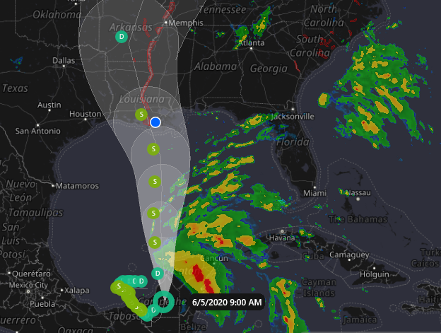
2. Cristobal is forecast to re-emerge over the southern Gulf of
Mexico later today and move northward over the central and northern
Gulf of Mexico over the weekend. There is a risk of tropical storm
force winds this weekend from Louisiana to the western Florida
Panhandle and a risk of dangerous storm surge from Louisiana to the
Florida Big Bend. These hazards will arrive well in advance of and
extend well east of Cristobal’s center. Storm surge and tropical
storm watches will likely be issued for a portion of the U.S. Gulf
Coast later today.
3. Heavy rainfall will spread into portions of the Gulf Coast from
east Texas to Florida this weekend into early next week, with areas
of flash flooding possible.
FORECAST POSITIONS AND MAX WINDS
INIT 05/0900Z 18.8N 90.1W 30 KT 35 MPH
12H 05/1800Z 20.1N 90.1W 30 KT 35 MPH…INLAND
24H 06/0600Z 22.0N 90.3W 35 KT 40 MPH…OVER WATER
36H 06/1800Z 23.8N 90.4W 40 KT 45 MPH…OVER WATER
48H 07/0600Z 25.7N 90.3W 45 KT 50 MPH…OVER WATER
60H 07/1800Z 27.6N 90.4W 50 KT 60 MPH…OVER WATER
72H 08/0600Z 29.6N 91.2W 45 KT 50 MPH…INLAND
96H 09/0600Z 34.0N 92.5W 30 KT 35 MPH…INLAND
120H 10/0600Z 40.0N 90.0W 25 KT 30 MPH…INLAND
$$
Forecaster Zelinsky


Leave a Reply