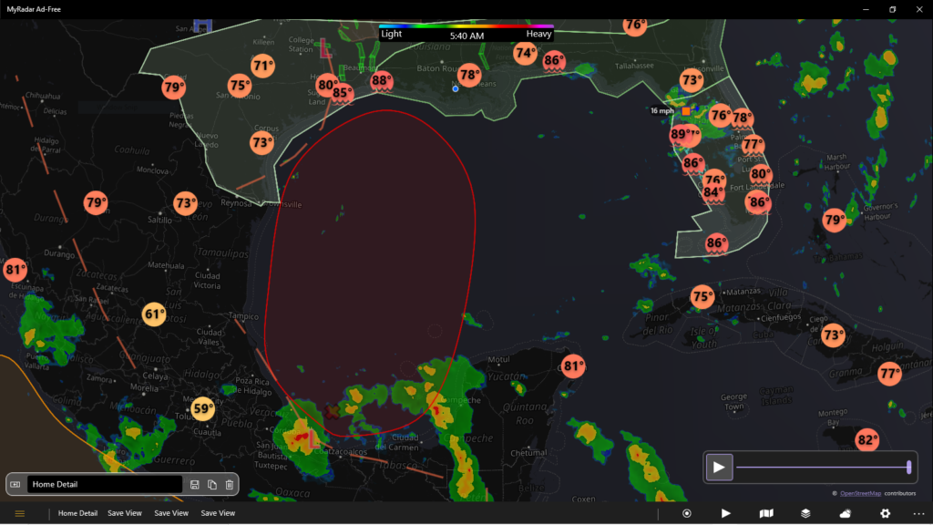
The weather map looks terrible, but things don’t seem to be that bad. For one, there is a weak high pressure system hanging out in the central GoM until “Mid-Week,” according to NOAA. I understand that tomorrow is “hump day” and thus, mid-week. But, if you look at the satellite imagery the central portion of the GoM is clear with all the nasty stuff down by the Yucatan Peninsula.
The NHC is still rating it at a 70% chance of development over the next 5 days, but only 20% chance for the next two days. The data tells me that if there is going to be a storm, it will not develop for at least 3 days. During those three days, it will drift toward the Louisiana/Texas coasts.
Given the temperature of the GoM, I would expect rapid development after day 3 (Thursday). Hopefully, by then, it will be next to a coast, rapidly make landfall, and rapidly dissipate. Where the disturbance is, the proximity to the coast, and the pressure of the center will be the data points to watch and examine closely Thursday, June 17th.
We will likely have a fair amount of rain with this storm. It is hoarding a lot of moisture.
Below it the NHC’s GoM portion of the Atlantic Tropical Discussion from this morning.
Thanks for reading,
Jay C. “Jazzy J” Theriot
it continues to a 1009 mb low pressure center that is near
20N95W, reaching 18N91W in the Yucatan Peninsula of Mexico.
Precipitation: scattered to numerous strong is within 60 nm on
either side of the line that runs from NW Guatemala, toward the
NNW, for 240 nm. Widely scattered moderate to isolated strong is
elsewhere from 23N southward from 88W westward, in the SW corner
of the Gulf of Mexico. Gradual development of this low pressure
center is possible during the next couple of days, while it
meanders near the coast of Mexico. The low pressure center
should begin to move northward by midweek. It is likely for a
tropical depression to form late in the week, when the low
pressure center moves across the central or northwestern Gulf of
Mexico. Heavy rainfall is possible in parts of Central America,
and in parts of southern Mexico, during the next several days.
It is possible that heavy rains may begin to impact parts of the
northern Gulf of Mexico coast on Friday. Please, consult all
weather bulletins from your local meteorological service for
more information.
An upper level trough is moving through the easternmost part of
the Gulf of Mexico, including on top of Florida. Precipitation:
Scattered moderate to isolated strong is in the Bahamas from 25N
northward. Isolated to widely scattered moderate, and locally
strong, are elsewhere from 20N northward from 70W westward in
the Atlantic Ocean, crossing Florida, and continuing to 92W in
the Gulf of Mexico.
Weak high pressure ridging will remain in the central Gulf of
Mexico into mid-week, supporting mainly gentle to moderate
anticyclonic winds across the basin. Broad low pressure in the
Bay of Campeche should begin to move northward by midweek. It is
likely for a tropical depression to form late in the week, when
the low pressure center moves across the central or northwestern
Gulf of Mexico.


Leave a Reply