
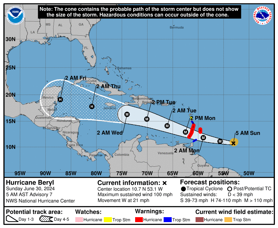
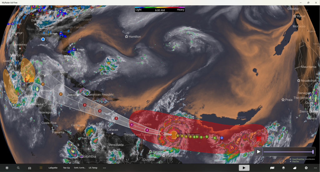
2024 Beryl now projected to gain category 4 status July 1st, and category 3 status midday on June 30th, 2024. This is a 22% increase of the forecasted maximum sustained winds on July 2nd, the date Beryl is forecast to reach her maximum intensity.
Winds
Forecast Advisory #3, put the maximum sustained winds on July 2nd at 1 am CST to be 95 kts. They are now forecast to be earlier, at 1 pm CST on July 1st at 115 kts (132 mph) with gusts to 140 kts (161 mph).
Path
The path has been changed, or solidified in its scope, to be slightly further south, away from Cuba and into the central Caribbean. Beryl is currently projected to make landfall at a category 2 strength around Cozumel, Yucatan.
There is some indecision on the ultimate final landfall so we must watch Beryl for possible destruction on a final landfall somewhere in the Gulf of Mexico. Should the path turn more to the north, a US landfall is not out of the question.
Jazzy J
000
WTNT22 KNHC 300854
TCMAT2
HURRICANE BERYL FORECAST/ADVISORY NUMBER 7
NWS NATIONAL HURRICANE CENTER MIAMI FL AL022024
0900 UTC SUN JUN 30 2024
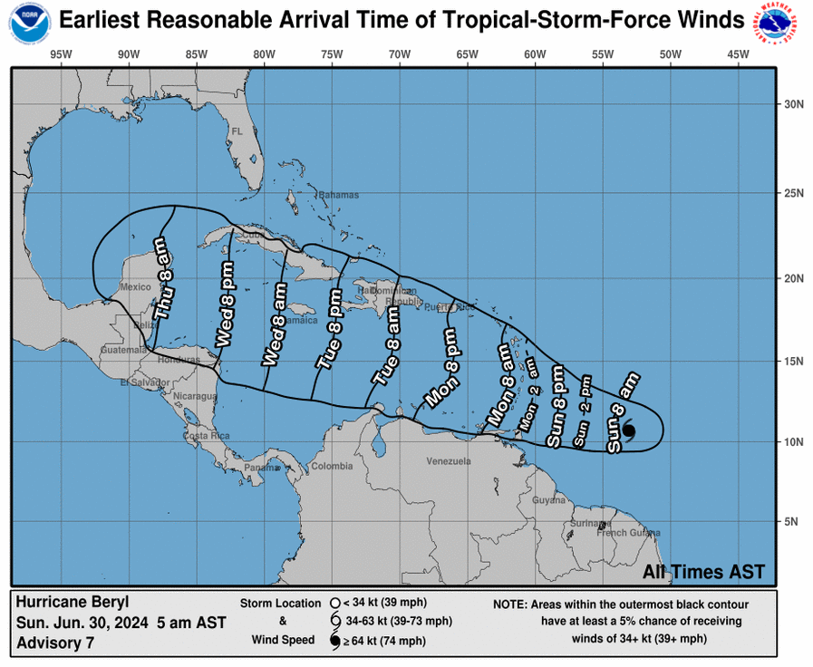
HURRICANE CENTER LOCATED NEAR 10.7N 53.1W AT 30/0900Z
POSITION ACCURATE WITHIN 20 NM
PRESENT MOVEMENT TOWARD THE WEST OR 280 DEGREES AT 18 KT
ESTIMATED MINIMUM CENTRAL PRESSURE 981 MB
EYE DIAMETER 20 NM
MAX SUSTAINED WINDS 85 KT WITH GUSTS TO 105 KT.
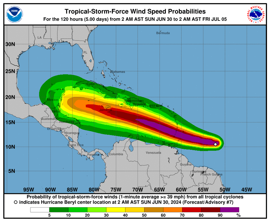
64 KT....... 15NE 10SE 0SW 15NW.
50 KT....... 30NE 20SE 15SW 30NW.
34 KT....... 70NE 40SE 30SW 50NW.
12 FT SEAS..135NE 45SE 30SW 120NW.
WINDS AND SEAS VARY GREATLY IN EACH QUADRANT. RADII IN NAUTICAL
MILES ARE THE LARGEST RADII EXPECTED ANYWHERE IN THAT QUADRANT.
REPEAT...CENTER LOCATED NEAR 10.7N 53.1W AT 30/0900Z
AT 30/0600Z CENTER WAS LOCATED NEAR 10.5N 52.2W
FORECAST VALID 30/1800Z 11.1N 55.7W
MAX WIND 100 KT...GUSTS 120 KT.
64 KT... 20NE 10SE 10SW 20NW.
50 KT... 30NE 20SE 20SW 30NW.
34 KT... 70NE 50SE 30SW 60NW.
FORECAST VALID 01/0600Z 11.8N 59.0W
MAX WIND 115 KT...GUSTS 140 KT.
64 KT... 20NE 10SE 10SW 20NW.
50 KT... 40NE 30SE 20SW 30NW.
34 KT... 90NE 50SE 40SW 70NW.
FORECAST VALID 01/1800Z 12.9N 62.5W
MAX WIND 115 KT...GUSTS 140 KT.
64 KT... 30NE 20SE 10SW 20NW.
50 KT... 50NE 30SE 20SW 40NW.
34 KT...110NE 80SE 40SW 90NW.
FORECAST VALID 02/0600Z 14.1N 66.1W
MAX WIND 110 KT...GUSTS 135 KT.
64 KT... 30NE 20SE 10SW 20NW.
50 KT... 50NE 40SE 20SW 40NW.
34 KT...110NE 90SE 40SW 90NW.
FORECAST VALID 02/1800Z 15.4N 70.1W
MAX WIND 105 KT...GUSTS 130 KT.
50 KT... 50NE 40SE 20SW 40NW.
34 KT...110NE 90SE 40SW 90NW.
FORECAST VALID 03/0600Z 16.3N 74.0W
MAX WIND 100 KT...GUSTS 120 KT.
50 KT... 50NE 30SE 20SW 40NW.
34 KT...120NE 90SE 40SW 90NW.
EXTENDED OUTLOOK. NOTE...ERRORS FOR TRACK HAVE AVERAGED NEAR 125 NM
ON DAY 4 AND 175 NM ON DAY 5...AND FOR INTENSITY NEAR 15 KT EACH DAY
OUTLOOK VALID 04/0600Z 17.8N 80.9W
MAX WIND 90 KT...GUSTS 110 KT.
50 KT... 40NE 20SE 10SW 40NW.
34 KT...120NE 70SE 40SW 90NW.
OUTLOOK VALID 05/0600Z 19.1N 87.1W
MAX WIND 85 KT...GUSTS 105 KT.
50 KT... 40NE 20SE 10SW 40NW.
34 KT...120NE 70SE 40SW 90NW.
REQUEST FOR 3 HOURLY SHIP REPORTS WITHIN 300 MILES OF 10.7N 53.1W
INTERMEDIATE PUBLIC ADVISORY...WTNT32 KNHC/MIATCPAT2...AT 30/1200Z
NEXT ADVISORY AT 30/1500Z
$$
FORECASTER BLAKE
Leave a Reply